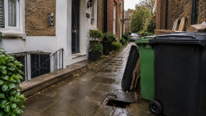
Drain mapping in Kingston provides a clear picture of how underground drainage systems are arranged beneath a property. Many homeowners and property managers have little or no information about where their drains run until a problem occurs.
Whether you are planning building work, investigating recurring drainage issues or purchasing a property, professional CCTV drain surveys in Kingston upon Thames can help create an accurate drainage map and identify hidden defects before they become expensive problems.
What Is Drain Mapping?
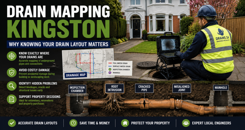
Drain mapping is the process of identifying and recording the location, direction and depth of underground drainage systems.
Using specialist equipment, drainage engineers trace pipe routes and create a detailed understanding of how wastewater and surface water move through the property.
A drainage map typically shows:
- inspection chambers
- manholes
- pipe routes
- drainage connections
- changes in pipe direction
- shared drainage systems
As a result, property owners gain a much clearer understanding of their drainage infrastructure.
Why Drain Mapping Is Important
Many drainage systems have been modified over decades. Consequently, plans are often inaccurate or no longer available.
Drain mapping helps prevent costly mistakes and provides valuable information before any work begins.
Planning Extensions and Building Projects
Before building an extension, conservatory or driveway, it is important to understand where drains are located.
Knowing the drainage layout helps avoid accidental damage and allows projects to comply with building regulations.
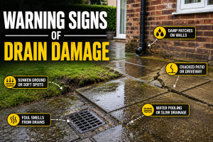
Identifying Hidden Drainage Problems
Drain mapping often reveals unexpected connections, abandoned pipework or previously unknown drainage routes.
Therefore, engineers can identify issues more quickly and recommend appropriate solutions.
Supporting Property Purchases
Homebuyers increasingly request drainage investigations before completing a purchase.
Accurate drain mapping provides confidence that there are no hidden surprises beneath the property.
How Drain Mapping Is Carried Out
Modern drain mapping uses a combination of CCTV technology and tracing equipment.
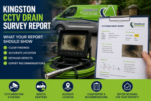
CCTV Drain Surveys
Engineers insert specialist cameras into the drainage system to inspect the internal condition of the pipes.
This process allows engineers to locate defects, identify connections and trace drainage routes accurately.
Drain Tracing Equipment
Electronic tracing equipment follows the path of underground pipes from the surface.
As a result, engineers can create accurate maps showing the location of the drainage network.
Mapping and Reporting
Once the survey is complete, the information is compiled into a drainage plan.
Property owners receive a clear overview of the drainage layout and any issues discovered during the inspection.
Common Situations Where Drain Mapping Helps
Drain mapping is useful in many situations.
For example:
- planning extensions
- buying or selling property
- investigating recurring blockages
- locating hidden manholes
- identifying shared drains
- preparing for drainage repairs
In each case, accurate information helps reduce risk and avoid unnecessary costs.
Benefits of Professional Drain Mapping
Professional drain mapping offers several advantages.
Better Decision Making
Accurate drainage information helps homeowners and contractors plan work more effectively.
Faster Problem Diagnosis
Engineers can identify faults more quickly when the drainage layout is clearly understood.
Reduced Excavation
Knowing where drains are located reduces unnecessary digging and disruption.
Improved Repair Planning
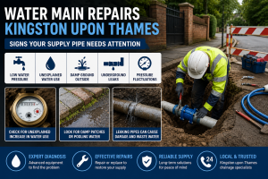
When repairs are required, professional drain repairs in Kingston upon Thames can be planned more efficiently using accurate drainage data.
When to Arrange a Drain Mapping Survey
If you are planning building work, purchasing a property or dealing with ongoing drainage issues, a drain mapping survey is often a worthwhile investment.
In some situations, drainage problems may require urgent investigation. Professional emergency drainage services in Kingston upon Thames can respond quickly and identify issues before they escalate.
For guidance on building near drains and drainage responsibilities, visit: https://www.gov.uk/building-regulations-approval
FAQs
What is drain mapping?
Drain mapping identifies the location and layout of underground drainage systems using CCTV surveys and tracing equipment.
Why is drain mapping useful before an extension?
Drain mapping helps identify pipe locations and prevents accidental damage during construction work.
Can drain mapping find hidden drainage problems?
Yes. Drain mapping often reveals unknown pipework, hidden connections and drainage defects.
Is drain mapping different from a CCTV drain survey?
A CCTV survey inspects pipe condition, while drain mapping focuses on identifying the layout and route of the drainage system.